Barndominium Builders in Barren County, KY
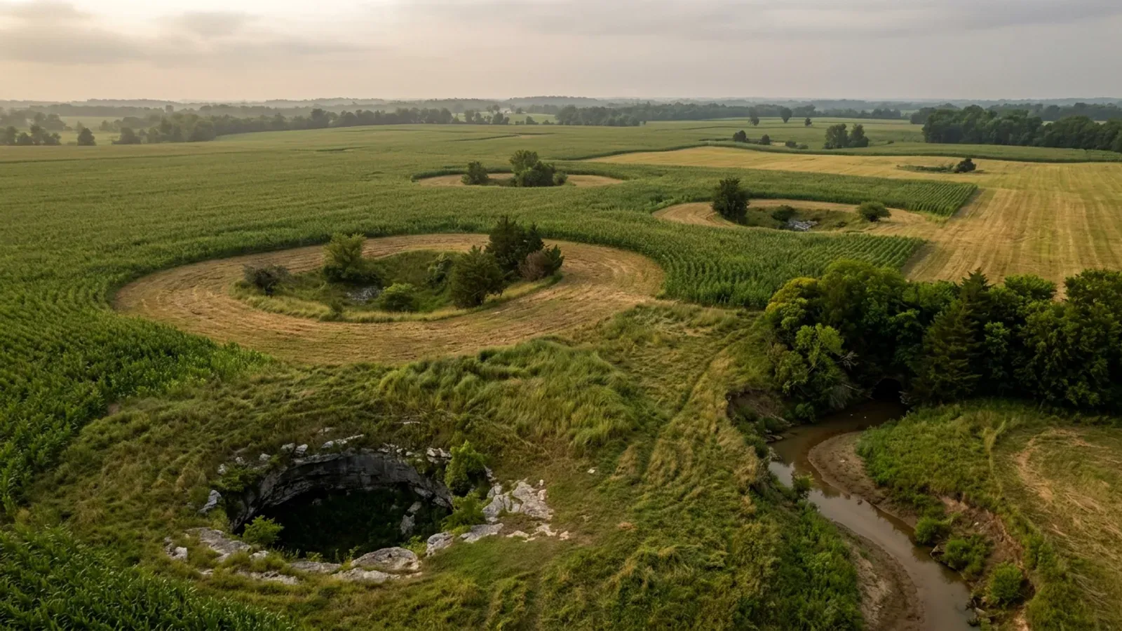
Barren County has more farms than any other county in Kentucky, and it sits on the sinkhole plain. Both halves of that sentence are the page. USDA's 2022 Census of Agriculture counts 1,621 farms here — the largest count in the Commonwealth — across 230,539 acres, and the middle of that distribution is exactly the tract a barndominium buyer is looking for: 665 farms between 50 and 179 acres and 560 more between 10 and 49. The ground under them is Western Pennyroyal karst, the largest and most heavily sinkholed of the karst regions the Kentucky Geological Survey maps, and a corner of Mammoth Cave National Park reaches into the north-west of the county. KGS's own model karst ordinance, Information Circular 25, lists the structures that should not be sited in a sinkhole area with a cover-collapse history, and the first two entries are buildings with soil-bearing foundations and buildings covering thousands of square feet of impermeable surface. A post-frame or steel building on a monolithic slab is both at once. The same document is the honest counterweight: nearly all karst parcels have buildable ground, and the work is choosing where on the parcel to put the pad rather than pouring where the field looks flattest. What makes Barren different from its neighbours is the regulatory shape. It is one of the minority of Kentucky counties that actually issues a residential building permit and inspects the house, out of a single office on South Green Street in Glasgow that covers the county and the cities of Glasgow, Cave City and Park City alike. But unincorporated Barren County has no zoning ordinance at all — a draft is circulating and has not been adopted — so outside the city limits there is no minimum lot size, no setback schedule and no cap on how big or how tall the shop can be. The binding local karst rule is not in a zoning code either. It is in the Joint City-County Planning Commission's Subdivision Regulations, which preserve sinkholes and the ground within twenty-five feet of the low point, and require a professional engineer's geotechnical report before anyone fills one.
Barren County at a glance
- County
- Barren
- Population
- 45,870
- ZIP codes
- 42141, 42142, 42127, 42160, 42152, 42123, 42156, 42130
- Site visits
- Site visits across the Barren River valley and the sinkhole plain — Barren, Metcalfe, Hart, Allen and Warren
Building conditions in Barren County
The building code is the same in every Kentucky county, and no local government may adopt or enforce a different one on a house — the Kentucky Residential Code says so in its own text. The design criteria are settled by the state too: the code prints a filled-in table covering all 120 counties, so your county's ground snow load, frost depth and seismic design category are published figures rather than something a local office decides. Ultimate design wind speed is 115 mph for every county in the state.
What changes from one county to the next is whether anyone checks. Kentucky makes permits, inspections and certificates of occupancy optional for a single-family home unless the local government has passed an ordinance requiring them, and it forbids the state from stepping in where none has. Twenty-five counties tell the state outright that they have no local building inspector, and in much of the rest the answer depends on an ordinance the county either passed or never did. Zoning is a separate, equally local choice — most Kentucky counties have never adopted any. What is below covers this county specifically: who issues the permit if anyone does, what the state's tables assign it, and what the ground does to a slab.
https://www.barrencounty.net/buildinginspector (Barren County Government's own Building Inspector page — office, jurisdiction, permits issued and the property maintenance board; read 6 Sep 2026) · https://www.barrencounty.net/_files/ugd/76b6e7_4f0c2df7ea5f42ba8d066f3c03207e97.pdf (Fee Schedule for Building, HVAC and Electrical Inspections — downloaded and text extracted with pdftotext, both -raw and -layout, 6 Sep 2026) · https://us.cloudpermit.com/gov/login (the county's permit portal) · https://dhbc.ky.gov/Documents/Barren%20County.pdf (DHBC county sheet, extracted with pdftotext -raw; a contact directory, not an ordinance register) · https://apps.legislature.ky.gov/law/statutes/statute.aspx?id=52659 · the City of Glasgow's own site at cityofglasgow.gov refuses automated requests with a forbidden response, so the county's page was used instead
https://www.nass.usda.gov/Publications/AgCensus/2022/Online_Resources/County_Profiles/Kentucky/cp21009.pdf (2022 Census of Agriculture, Barren County profile, FIPS 21009 — downloaded and extracted with pdftotext BOTH -raw and -layout on 6 Sep 2026. The -layout pass misaligns both the overview table and the farms-by-size table by one row, printing the -15 percent change against Land in farms and pairing the 500-to-999 count with the 1,000-plus row; the -raw pass is authoritative and its six size bands sum to 1,621, matching the published farm count) · farm-count ranking corroborated in research/statewide/geography-and-population.md · Warren comparison from research/entries/warren-county-ky.json and cp21227.pdf
https://jccpc-ky.com/wp-content/uploads/2024/04/Subdivision-Regulations-2024-Website.pdf (Joint City-County Planning Commission of Barren County, Subdivision Regulations, Design and Development Standards, approved 16 April 2024 — Sections 103.0 jurisdiction, 510.1, 510.2, 510.5, 802.4.4; downloaded and text extracted with pdftotext both -raw and -layout on 6 Sep 2026, and Section 510.2 reads identically in both passes) · https://jccpc-ky.com/documents/subdivision-regulations/ · https://kgs.uky.edu/kgsweb/olops/pub/kgs/IC25_12.pdf (Currens, J.C., 2012, KGS Information Circular 25, Series XII, Sections 1.24, 1.34, 4.12, 4.21; transcribed in research/statewide/soils-karst-and-slopes.md)
https://jccpc-ky.com/documents/zoning-regulations/ (the Commission's own zoning page, listing Glasgow, Park City and Cave City ordinances and no county ordinance; read 6 Sep 2026) · https://jccpc-ky.com/announcements/proposed-barren-county-zoning-ordinance-draft/ · https://jccpc-ky.com/wp-content/uploads/2026/08/2026-Barren-County-Zoning-Ordinance-Working-Draft.pdf (working draft — Preface, Sections 1.02, 3.5, 3.6 Agricultural District dimensional table and 18.3.13; downloaded and extracted with pdftotext both -raw and -layout on 6 Sep 2026, and the AG table's values sit on the same rows in both passes) · https://jccpc-ky.com/announcements/barren-county-land-use-committee-meetings-public-meeting/ · https://jccpc-ky.com/ · KRS Chapter 100, https://apps.legislature.ky.gov/law/statutes/chapter.aspx?id=38316
https://www.uky.edu/KGS/water/library/gwatlas/Barren/Topography.htm and https://www.uky.edu/KGS/water/library/gwatlas/Barren/Overview.htm and https://www.uky.edu/KGS/water/library/gwatlas/Barren/Waterquality.htm (Carey, D.I., and Stickney, J.F., 2002, Groundwater Resources of Barren County, Kentucky: Kentucky Geological Survey County Report 5, Series XII, quoting McGrain and Currens 1978; all three pages read 6 Sep 2026) · https://www.uky.edu/KGS/water/library/gwatlas/Barren/Karst.htm · https://www.uky.edu/KGS/water/library/gwatlas/wprkarst.html (KGS on the Western Pennyroyal as the largest karst region, with the state's longest caves and densest sinkhole development)
https://dhbc.ky.gov/Documents/2018%20Kentucky%20Residential%20Code%203d%20Ed.pdf — Table R301.2(1) (ground snow, ultimate wind, weathering, termite), Table R301.2.2.1 Seismic Design Categories–Site Class D, and Table R403.1.4 Minimum Frost Protection Depth for Kentucky; all three transcribed county-by-county in research/statewide/design-criteria-and-climate.md, where the seismic table was re-extracted in raw content-stream order after -layout mis-paired its first column · https://www.barrencounty.net/_files/ugd/76b6e7_b065a2402f2b4a67ae34ffe0139d2ccf.pdf (Barren County KY Residential Code Permit Checklist, items 6 and 20 — downloaded and extracted with pdftotext -raw, 6 Sep 2026)
Also worth knowing before you build in Barren County
- Septic on the sinkhole plain: 70 feet from a throat, and everything downslope of the sideslope midpoint, is unsuitable
- The Barren River District Health Department issues the on-site sewage permit, covering eight counties — Barren, Butler, Edmonson, Hart, Logan, Metcalfe, Simpson and Warren. The Barren County office is at 200 South Green Street in Glasgow on 270-651-8321, environmental services at option 3, and it shares that building with the building inspector and the planning commission. The sequence matters here more than in most counties, because Barren County's own residential permit checklist lists a septic release from the health department as a prerequisite for the building permit: no septic release, no permit, no house. What decides a parcel is Kentucky's on-site sewage regulation, 902 KAR 10:085, and its karst clause is blunt: an area closer than seventy feet to an open sinkhole throat, downslope from the sinkhole sideslope midpoint, or subject to flooding damage shall be considered unsuitable. Read that as three separate disqualifiers. The seventy-foot rule is a fixed radius and easy to plan around. The downslope-of-the-sideslope-midpoint rule is not a radius at all, and on the broad shallow depressions of the Pennyroyal sinkhole plain it can sterilise a large share of a field that looks perfectly ordinary from the road. And seventy feet is a floor, not a ceiling — some Kentucky jurisdictions elsewhere in the karst belt impose considerably larger separations by local rule, so ask the district what it applies here. On this ground the working order is: sinkhole map, then site evaluation, then septic field, then house siting, then floor plan. Get the evaluation done before the deed, not after.
- The flood insurance discount here is outside the city, not inside it — unincorporated Barren is CRS Class 9
- FEMA's Community Rating System eligible communities list, effective 1 April 2026, carries Barren County at CID 210334, a CRS entry date of 1 October 2013, a current Class 9 and a 5 percent discount on flood insurance premiums in the Special Flood Hazard Area. Neither the City of Glasgow nor the City of Cave City appears anywhere in the Kentucky block of that list. That is the reverse of the usual Kentucky pattern, where a city out-rates the county around it — Warren County and Bowling Green are both Class 7 at 15 percent — and it means the premium discount in Barren County is earned on unincorporated ground. All three communities do participate in the NFIP: FEMA's Kentucky community status book shows unincorporated Barren County at CID 210334 and Cave City at CID 210011 with initial FIRMs of 3 May 2011, and Glasgow at CID 210007 with an initial FIRM of 1 May 1987, all on a current effective map dated 3 May 2011. The Joint City-County Planning Commission administers the floodplain programme for the county, Glasgow, Cave City and Park City, with Kevin Myatt as Local Floodplain Manager on 270-659-0661, and it names the local flood mechanisms as rivers, creeks, flash flooding and overloaded storm and karst systems. That last one is the Pennyroyal signature: water coming back up out of a closed depression a mile from any stream when the conduit below is already full, which a FIRM does not always show. The county's subdivision regulations go beyond the NFIP minimum at Section 510.1, requiring that a structure be at least two feet above the base flood elevation and that Division of Water requirements be obtained before a building permit issues. And that is the standing state fact: Kentucky requires a separate state Division of Water floodplain construction permit for work in the base floodplain under KRS 151.250 and 401 KAR 4:060 Section 2, applied for on form DOW 7116 — it stacks on the local permit rather than replacing it. Barren River Lake, the Corps of Engineers flood-control reservoir on the Barren River, holds a normal pool of 552 feet.
- You can check your own parcel's karst class before you make an offer — and know what the map cannot tell you
- The Kentucky Geological Survey publishes a Karst Potential Index as a live layer in its Geologic Map Information Service, and the deep link with the karst layer already switched on pans and zooms to a single tract. It classifies the bedrock in three plain classes: INTENSE, meaning high potential for karst development and possibly mature karst including caves, sinkholes and springs where the units crop out; PRONE, meaning moderate potential, variable and dependent on site-specific conditions; and NONKARST, meaning limited or no potential. The classification is built from lithology — the percentage of calcium carbonate in the carbonate portion of the unit, grain size, bedding thickness and insoluble components — mapped from the 1:500,000-scale geologic map of Kentucky. Two limits deserve stating. KGS notes that its finer 1:24,000-scale karst potential layer has been pulled from the viewer while the data is improved, so what a reader gets today is the 1:500,000 statewide layer. And more fundamentally, the index tells you the bedrock unit has karst potential. It cannot tell you whether there is a void, a soil-filled throat or a pinnacled rockhead under the three thousand square feet you are about to pour. Only borings on the actual foundation footprint, with geophysics between them, can do that — and the previously filled and graded-over sinkhole is the classic trap here, because the pad above it looks perfect. IC-25 Section 4.12 requires filled sinkholes to be shown wherever there is any evidence of their location, for exactly that reason.
- The county's own permit checklist expects a pole building — and has a rule for fill that most codes do not
- Barren County's Kentucky Residential Code Permit Checklist is unusually candid about what people actually build here, and it is worth reading before designing. Item 19 asks the applicant to state the foundation type and lists Crawlspace, Basement, Slab, Pole Bldg. and Post and Pier among the options, so post-frame construction is a recognised category at the counter rather than an argument to be had. Item 20 is the one that matters on karst: if more than twelve inches of fill has been brought onto the building site, a compaction test is required before the footing inspection and a copy of the report must be submitted. Item 6 requires all trusses and rafters to carry metal straps or ties, or equivalent listed screws, for uplift. Engineered materials such as trusses and laminated veneer lumber require spec sheets, and the framing inspection will not be done until they are in the office; a design professional is required for any building practice not specifically addressed in the residential code, which the checklist illustrates with a log home and a storage-container building. Plans need not be architect-stamped, but a floor plan showing door and window sizes, hallway and stairway widths and room classification must be submitted for review. A plot plan prepared by a licensed surveyor is required and cannot be self-drawn, with a waiver available only where the setbacks are doubled, the lot was subdivided before 1978, or the parcel is ten acres or more. The applicant signs and has notarised an affidavit under KRS 198B.060(10) that every contractor and subcontractor carries Kentucky workers' compensation and unemployment insurance, with a penalty of up to $4,000 for non-compliance. And entrance and culvert location and size must be approved by the road department — the County Road Department on 270-678-2832, or the state highway district on 270-746-7898 where the drive meets a state route.
- Barren is an EPA radon Zone 1 county, and the Kentucky code requires nothing about it
- EPA maps Barren as one of only thirty Kentucky counties in radon Zone 1, its highest predicted indoor radon class. The pattern behind that list is not a coincidence and it is worth stating plainly: Kentucky's Zone 1 map is essentially its karst map — the Inner Bluegrass plus the Pennyroyal karst belt of Warren, Barren, Hart, Allen, Monroe, Metcalfe, Cumberland, Adair, Green, Taylor, Casey, Russell and Pulaski. KGS itself lists radon infiltration into homes as a karst hazard, beside sinkhole flooding and sudden cover collapse, because the same solution-widened joints that drain a sinkhole also vent soil gas. What Kentucky does not do is regulate it: the Kentucky Residential Code adopts appendices K, R and S and does not adopt Appendix F, Radon Control Methods, so radon-resistant construction is required nowhere in the Commonwealth. On a slab-on-grade building with a large footprint that is a decision worth making deliberately. A passive sub-slab depressurisation rough-in — the gas-permeable layer, the membrane, the tee and the stack — costs very little while the slab is still open and a great deal to retrofit. KRS 309.436(9) expressly exempts a building contractor installing vent pipes during construction of a home from Kentucky's radon licensing regime, so the rough-in is a builder's ordinary work; the same statute polices the title, so nobody without a mitigation registration should be described as a certified mitigation contractor.
- Kentucky built an insurance fund for the hazard Barren County does not have, and none for the hazard it does
- Kentucky's Mine Subsidence Insurance Fund covers counties whose fiscal courts voted the coverage in, and in those counties KRS 304.44-030 puts the endorsement on every property policy automatically unless the insured waives it in writing. Barren County is not one of the thirty-seven counties on the Department of Insurance's current list — which is unsurprising, because it is not a coal county. What is worth noticing is that two counties in Barren's own health district are: Edmonson and Butler both participate, as does Hancock and the whole western coalfield tier. So a Barren County buyer crossing into Edmonson gets an automatic subsidence endorsement, and a Barren County buyer stays home and gets nothing comparable for the hazard actually under the parcel. Kentucky created a statutory reinsurance fund for underground coal-mine collapse and nothing equivalent for karst, even though KGS puts karst geohazard losses at roughly twenty million dollars a year statewide. The standard homeowner's earth-movement exclusion, which the Department of Insurance quotes in its own mine-subsidence brochure, is broad enough to swallow a sinkhole collapse, and the Kentucky Real Estate Commission's Form 402 seller's disclosure asks about soil stability, drainage and erosion while asking nothing at all about sinkholes, caves or undermining. Sinkhole cover in Kentucky is a voluntary endorsement. Put the question to your agent in writing before closing, and check the current county list with the Department of Insurance rather than relying on any published copy of it, because the list has changed before.
- Mammoth Cave reaches into the county, and what leaves your roof reaches the cave
- KGS's county groundwater report records that a small part of Mammoth Cave National Park sits in the upland plateau area of north-western Barren County. There is no separate park-boundary building rule that follows from that — the permit, the septic release and the subdivision plat are the same on either side of the county — but the hydrology does not respect the boundary either, and that is the part worth understanding before you decide where the downspouts go. On the sinkhole plain, surface drainage is rare; rainfall goes underground through sinkholes and swallow holes and travels in conduits to springs on the Green and Barren Rivers, and the Kentucky Division of Water rates Barren County as having areas of moderate to high sensitivity to groundwater pollution. KGS puts the mechanism plainly: swallow holes are often large enough to swallow tree limbs and cobbles, waste dumped into sinkholes easily reaches underground streams, and sewage, paint, motor oil and pesticides are not filtered from water entering a karst aquifer. A barndominium is a point source simply by existing — several thousand square feet of metal roof plus a gravel apron and a long drive converts a diffuse, vegetated recharge area into concentrated discharge, which is exactly the trigger KGS and USGS both name for new sinkhole formation. There is a regulatory edge to it too: IC-25 Section 5.51 states that increasing a sinkhole's recharge rate by excavating the throat or installing dry wells classifies the modified sinkhole as a Class V injection well under EPA rules, and Kentucky's underground injection control primacy covers Class II wells only, so Class V wells here are implemented directly by EPA Region 4 with inventory information due before construction. The county's own subdivision drainage submittal already asks engineers to show where and at what rim elevation all drywells and sinkhole boxes will be. Route the roof water away from any closed depression, and never make water disappear faster by opening the throat.
- One building on South Green Street holds the permit desk, the planning desk and the septic desk
- Barren County's approvals are unusually easy to walk between, which is a practical advantage worth using. The building and electrical inspector's office is at 200 South Green Street, Suite 200. The Joint City-County Planning Commission is at 200 South Green Street, Suite 201, with a second address at 126 East Public Square. The Barren County Health Department, the Barren River District office that issues the septic permit and the septic release the building permit depends on, is at 200 South Green Street. One trip can start all three conversations. The jurisdictional split, by contrast, is the thing to establish before you design: the building permit is the same office inside Glasgow, Cave City and Park City as it is out in the county, but zoning is not. Glasgow, Cave City and Park City each have their own zoning ordinance administered by the Commission, and unincorporated Barren County has none. The county's permit checklists carry the difference explicitly, with different land-disturbance thresholds triggering planning review in each city — Glasgow at more than 10,000 square feet disturbed or 3,400 square feet of new impervious area, Cave City at 20,000 and 5,000, and Park City at 25,000 and 5,000 — and a separate question for Glasgow's Downtown Public Square Historic Overlay District. Establish which side of the city line your parcel is on first, then design. The Fiscal Court's code of ordinances is published through American Legal Publishing, whose site refuses automated access, so ordinance text itself is a phone call to the Judge/Executive's office or the Fiscal Court on 270-651-3338.
https://apps.legislature.ky.gov/law/kar/titles/902/010/085/ (902 KAR 10:085, on-site sewage disposal systems — the karst suitability clause, transcribed and cross-checked in research/statewide/land-water-and-septic.md) · https://www.barrenriverhealth.org/locations/barren-county-health-department (the Barren County office, address, phone and the eight-county district; read 6 Sep 2026) · https://www.barrenriverhealth.org/services/onsite-sewage · https://www.barrencounty.net/_files/ugd/76b6e7_b065a2402f2b4a67ae34ffe0139d2ccf.pdf (the county checklist making the septic release a prerequisite) · https://dhbc.ky.gov/Documents/Barren%20County.pdf (the DHBC sheet routes the environmentalist row to the Barren County Health Department at 200 S Green Street)
https://www.fema.gov/sites/default/files/documents/fema_crs_eligible-communities_042026.pdf (FEMA CRS Eligible Communities, effective 1 April 2026 — fema.gov refuses curl requests, so the PDF was retrieved through WebFetch, saved locally and extracted with pdftotext. Read with -raw: the -layout pass shifts the class column and reports Warren County as Class 8, which contradicts the established Class 7; -raw gives Barren County 9 and 5, Warren County 7 and 15, and Bowling Green 7 and 15, and is authoritative) · https://www.fema.gov/cis/KY.html (Kentucky community status book — CIDs and FIRM dates; reached through WebFetch after curl was refused) · https://jccpc-ky.com/flood-plain-info/ (Local Floodplain Manager and the named flood mechanisms) · https://jccpc-ky.com/wp-content/uploads/2024/04/Subdivision-Regulations-2024-Website.pdf Section 510.1 · https://apps.legislature.ky.gov/law/statutes/statute.aspx?id=54097 · https://eec.ky.gov/Environmental-Protection/Water/FloodDrought/Pages/default.aspx · normal pool elevation from https://www.uky.edu/KGS/water/library/gwatlas/Barren/Topography.htm; the Corps' Louisville District site refuses automated access
https://kgs.uky.edu/kygeode/geomap?gkarst=true (KGS Karst Potential Index viewer, deep link with the karst layer switched on — loaded 6 Sep 2026, HTTP 200, interactive map application, confirmed as a live page rather than a redirect) · https://kgs.uky.edu/kgsmap/helpfiles/karst_help.shtm (the three KPI classes, how they are derived, and KGS's own note that the 1:24,000 layer has been withdrawn for improvement; read 6 Sep 2026) · https://www.uky.edu/KGS/karst/karst_sinkhole.php · https://kgs.uky.edu/kgsweb/olops/pub/kgs/IC25_12.pdf Section 4.12
https://www.barrencounty.net/_files/ugd/76b6e7_b065a2402f2b4a67ae34ffe0139d2ccf.pdf (Barren County KY Residential Code Permit Checklist and Minimum Requirements for Permitting — downloaded and text extracted with pdftotext -raw on 6 Sep 2026) · https://www.barrencounty.net/_files/ugd/76b6e7_66695d06eadb482e9753dfb7b09c258b.pdf (the parallel KY Building Code Permit Checklist, which adds the Glasgow Downtown Public Square Historic Overlay District question) · https://www.barrencounty.net/buildinginspector · https://apps.legislature.ky.gov/law/statutes/statute.aspx?id=52659
https://www.epa.gov/sites/default/files/2014-08/documents/kentucky.pdf (EPA Map of Radon Zones, Kentucky — the 30 Zone 1 counties, transcribed in research/statewide/soils-karst-and-slopes.md section 7) · https://www.uky.edu/KGS/water/library/gwatlas/wprkarst.html (KGS listing radon infiltration among karst hazards) · https://kygs.uky.edu/geology/radon · https://dhbc.ky.gov/Documents/2018%20Kentucky%20Residential%20Code%203d%20Ed.pdf (adopted appendices K, R and S)
https://insurance.ky.gov/PPC/Documents/JAN%202025_Revised%20Mine%20Subsidence%20Insurance%20Fund%20080124.pdf (KDOI 37-county brochure, rev. 08/24 eff. 1/1/25, which does not list Barren but does list Butler and Edmonson; transcribed in research/statewide/soils-karst-and-slopes.md section 4) · https://insurance.ky.gov/ppc/Documents/bulletin0904minesubs092109.pdf (Bulletin 2009-04, the fiscal-court participation mechanism) · https://law.justia.com/codes/kentucky/chapter-304/subtitle-304-44/ · https://krec.ky.gov/Documents/KREC%20Form%20402%20-%20Sellers%20Disclosure%20of%20Property%20Condition.pdf · https://kgs.uky.edu/kgsweb/olops/pub/kgs/IC25_12.pdf Section 1.21
https://www.uky.edu/KGS/water/library/gwatlas/Barren/Topography.htm (KGS: a small part of Mammoth Cave National Park is in the upland plateau area of north-western Barren County) · https://www.uky.edu/KGS/water/library/gwatlas/Barren/Karst.htm (swallow holes, sinkhole throats and unfiltered contaminant transport) · https://www.uky.edu/KGS/water/library/gwatlas/Barren/Waterquality.htm (Division of Water groundwater sensitivity for Barren County) · https://jccpc-ky.com/wp-content/uploads/2024/04/Subdivision-Regulations-2024-Website.pdf (drainage submittal requiring drywell and sinkhole box rim elevations) · https://kgs.uky.edu/kgsweb/olops/pub/kgs/IC25_12.pdf Sections 5.01, 5.20, 5.51 · https://epa.gov/uic/underground-injection-control-epa-region-4-al-fl-ga-ky-ms-nc-sc-and-tn · https://www.usgs.gov/special-topics/water-science-school/science/sinkholes
https://www.barrencounty.net/buildinginspector · https://jccpc-ky.com/contact-us/ and https://jccpc-ky.com/ (Commission addresses and phone) · https://www.barrenriverhealth.org/locations/barren-county-health-department · https://www.barrencounty.net/_files/ugd/76b6e7_66695d06eadb482e9753dfb7b09c258b.pdf and https://www.barrencounty.net/_files/ugd/76b6e7_b065a2402f2b4a67ae34ffe0139d2ccf.pdf (the per-city land-disturbance thresholds and the historic overlay question) · https://www.barrencounty.net/document-center-1 (the county directs ordinance lookups to amlegal.com; both www.amlegal.com/codes/client/barren-county_ky/ and codelibrary.amlegal.com refused automated requests on 6 Sep 2026 and were not pursued further) · https://cavecity.ky.gov/our-city/Pages/Planning-and-Zoning.aspx

The expensive surprises are in the ground, not the building
What moves a Kentucky budget is usually below grade, and more often than not it is what the ground is sitting on rather than the ground itself. The Kentucky Geological Survey says 92 of the state's 120 counties contain karst — limestone that dissolves — across four named areas: the Western Pennyroyal around Bowling Green and Hopkinsville, the Inner Bluegrass around Lexington, the Eastern Pennyroyal through Somerset and Monticello, and Pine Mountain in the south-east. On karst, KGS's own model ordinance for local governments lists the structures that should not be sited in sinkhole areas, and the list is buildings with soil-bearing foundations and buildings that cover thousands of square feet with impermeable surface. A post-frame or steel building on a monolithic slab is both of those at once. KGS is equally clear that nearly all karst parcels still have buildable ground on them — so karst does not stop the build, it removes the option of siting the pad by eye. A filled and graded-over sinkhole is the classic trap, because the pad looks perfect.
In the two coal fields the question is undermining instead, and Kentucky treats it differently from everything else: mine subsidence coverage is added automatically to property policies in the counties whose fiscal court voted the fund in, with a written opt-out — thirty-seven of them — while karst collapse gets no fund at all and falls under the ordinary earth-movement exclusion. On slopes the surprise is geographic: KGS's landslide inventory puts Kenton, Campbell, Boone and Gallatin — the northern Kentucky counties opposite Cincinnati — near the very top, above most Appalachian counties, on Ordovician shale. Three of those four — Boone, Campbell and Kenton — are the only counties in the state with a line of their own in the residential code's bearing table, which raises the presumptive value for two named clay groups there and nowhere else. Everywhere else the table gives clay and silt a single presumptive figure, and a soils investigation becomes mandatory once the building official determines the real capacity is likely to be lower than it.
The same ground then sizes the septic system, and Kentucky does that from soil morphology — a certified inspector reading the profile in a backhoe pit — rather than from a percolation test, at 110 gallons a day per bedroom against an application rate taken from soil texture and structure. On a mound or other alternative design a measured permeability test can still be required. And on karst the septic regulation is blunter than the building code ever gets: it declares the ground within seventy feet of an open sinkhole throat unsuitable outright. The soil that needs a foundation engineer is usually the soil that complicates the drainfield, so the site work, the foundation and the septic get resolved together rather than one at a time. We price the dirt before we price the building.
What we build in Barren County
All seven services are available in Barren County. What a build costs depends far more on the parcel than on square footage, so we price against your land rather than publishing a rate card.
Barndominium Kits
We check barndominium kit packages against the wind, snow, frost and seismic criteria the Kentucky Residential Code publishes for your county.
Pole Barn Homes
Pole barn homes across Kentucky. KRC §R327 covers accessory barns, not houses — so a pole barn home is engineered by the code's own terms.
Custom Barndominium Plans
Barndominium plans drawn to Kentucky's published county design criteria — snow, wind, seismic, frost — with engineering where the code calls for it.
What a build looks like
Three stages every Barren County project passes through, from a raw parcel to a finished home. Site work first, because that is where the budget is decided.

The parcel
Karst and mine maps, the flood question, zoning where the county has any, and utility access — all checked before anything is drawn.
Pad and permit
Clearing, grading and a compacted pad, while the submittal works through whichever office issues the permit — and where no office does, through the approvals that still apply.

Frame to finish
Shell erected and dried in, then systems and interior finish — and the certified electrical inspection your utility needs before it will set a meter.
Those are the rules where you are building in Barren County. Tell us what you want to build and we will draw it to them.
Where we build around Barren County
Barren and the rural land around it. The buildable acreage for a project this size usually sits outside the city limits, and in Kentucky that line frequently decides whether anyone issues a permit at all, not merely who issues it.
Keep reading
The questions that usually come next once you know what Barren County allows.
Barndominium Cost Guide
Why the published spread runs from one end of the scale to the other, and which of it is the building rather than the ground.
Read itIs It Legal in Kentucky?
Whether your county inspects a house at all, what the farm-dwelling exemption really requires, and the approvals that reach you anyway.
Read itWhat a Pole Barn Home Costs
Post-frame against stick-built, and what the prescriptive post-frame section of the state code does and does not cover.
Read itNearby areas we build in
Others we cover nearby. They share the same statewide code and the same state-published design tables — but whether a house is permitted and inspected at all, whether the county zones, what the health department will accept for septic, and what the ground does to a foundation can all differ from one card to the next. Two counties that touch are not two versions of the same answer.
Building in Barren County: common questions
8 questions we get asked most often about building in Barren County. If yours is not on the list, ask it directly.
Do I need a building permit for a barndominium in Barren County?
Is it true a barn does not need a permit if it is on ten acres?
Can I build a shop bigger than the house?
How worried should I be about sinkholes on a Barren County parcel?
What design figures does a Barren County build have to meet?
Who issues the septic permit, and can a sinkhole cost me the parcel?
Is there actually land to buy in Barren County?
Does my builder need a licence in Barren County?
Building in Barren County?
Start with the plan. Tell us what you want to build and we will draw it, then confirm whether any office permits and inspects a house where your parcel is, what it will let you put there, and which line of the state's snow, frost and seismic tables your county falls on. That conversation costs nothing.