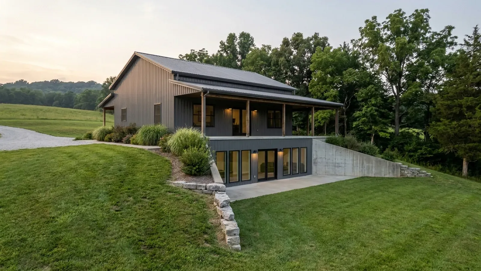
Barndominium with a Basement in Kentucky
From the road a walkout barndominium usually reads as a single-storey building: one gable end, a porch, a wide door, a low roofline sitting into the slope. Walk around to the downhill side and there is a second elevation nobody saw coming — a wall of glass and sliding doors under the deck, a patio, sometimes a shop bay cut straight into the bank. That is the shape Kentucky ground hands you for nothing across the Knobs, the Cumberland ridges and the Ohio River bluffs, and it is why almost every enquiry about a basement here turns out to be a question about the site rather than about the drawings. So this page is not a plan gallery. It is the four-way choice — slab, crawlspace, full basement, walkout — set against the five things Kentucky ground actually does underneath a wide, shallow, rigid building: dissolve, freeze to a depth the state publishes county by county, sit over old coal workings, flood, and hold radon.
What actually changes with this feature
The look is the easy part. These are the decisions that follow from it.
Two published depths, and the deeper one is not about frost
The Department of Housing, Buildings and Construction publishes minimum frost-protection depth county by county in Table R403.1.4 of the 2018 Kentucky Residential Code, Third Edition: 24 inches for all other Kentucky counties, rising to 27 inches in Bell, Clay, Knox, Lawrence and Owsley, 30 inches in Boone, Breathitt, Campbell, Harlan, Johnson, Kenton, Leslie, Magoffin and Perry, and 33 inches in Floyd, Knott, Letcher, Martin and Pike. Separately, DHBC's own post-frame section R327.3 calls for poured-in-place concrete footings under all posts with the top of the footing a minimum of 48 inches below finished grade. That is an embedment rule for a post-and-frame structure rather than a frost rule, and it is double the depth most of the state carries. Read the scope before you apply it: R327.1 limits that prescriptive section to single-storey residential accessory structures inside stated size caps, so a post-frame home sits outside it and is engineered by the code's own terms — but 48 inches is the number DHBC put in print for a post in Kentucky ground, and it reframes the arithmetic. Once you are already 48 inches down under every column, the marginal step to a crawlspace or a basement is smaller than most buyers assume.
The bearing value is published before anyone digs
A basement wall is a retaining wall with a house standing on it, and it is designed off a bearing number. DHBC's Table R401.4.1 gives presumptive load-bearing values to use in lieu of a complete geotechnical evaluation: crystalline bedrock 12,000 psf; sedimentary and foliated rock 4,000; sandy gravel and gravel 3,000; sand, silty sand, clayey sand and silty or clayey gravel 2,000; and clay, sandy clay, silty clay, clayey silt, silt and sandy silt 1,500. Footnote b sends you to a soils investigation wherever the building official determines in-place soils below 1,500 psf are likely. Footnote c is Kentucky-written and applies to three counties and two soil groups only: a 2,000 psf presumptive value for Boone, Campbell and Kenton counties, for CL and CH soils. Everywhere else the clay groups sit at 1,500 psf. Kentucky publishes the map that tells you which group you are on, too — the USDA Web Soil Survey engineering-properties report returns the same USCS symbols the table is indexed to.
In the base floodplain, the basement is the floor that counts
Kentucky's floodplain regulation, 401 KAR 4:060 Section 6(2)(a), requires that all new construction and substantial improvements of residential structures within the base floodplain have the lowest floor, including basement, elevated to at least the base flood elevation. The state rule is the base flood elevation with nothing added; individual communities may and often do require freeboard above it in their own floodplain ordinance, and the stricter local rule controls. Read that sentence with the words "including basement" left in and a below-grade storey inside the base floodplain largely answers itself. Two more Kentucky specifics belong in the same conversation: this is a state permit that stacks on the local one — the Division of Water reviews under KRS 151.250 and 401 KAR 4:060 on application form DOW 7116, and its floodplain general permit expressly excludes new residential structures, so a house needs the individual permit — and KRC Section R109.1.3 makes a mid-build hard stop of it, requiring documentation of the elevation of the lowest floor including basement, prepared and sealed by a registered design professional, upon placement of that floor and before any further vertical construction.
Kentucky ties basement insulation depth to its own frost table
This is a genuinely unusual link between two tables and almost nobody quoting national basement specs knows it is there. The Kentucky Residential Code's energy amendment N1101.2.1 requires walls associated with basements that make up the building thermal envelope to be insulated, inside or outside, from the top of the basement wall below grade down to the design frost depth in accordance with Section R403.1.4 — with an alternative for an unconditioned basement whose overhead floor is insulated instead. So the depth of your basement-wall insulation is set by which county you are in: 24 inches in most of the state, 33 inches in Floyd, Knott, Letcher, Martin or Pike. The Kentucky Residential Code points at the 2009 International Energy Conservation Code for residential energy, and all 120 Kentucky counties fall in a single climate zone under that edition's own county table — its prescriptive row gives basement wall R-10 continuous or R-13 cavity, crawlspace wall the same, and slab R-10 to a 2-foot depth. Those are the three foundation choices priced against each other on the same page of the same table.
Kentucky is a karst state before it is anything else, and the sentence everyone quotes about it is quoted wrong
The Kentucky Geological Survey states, in its own words, that ninety-two of Kentucky's 120 counties contain at least some areas of karst, and its Groundwater Atlas names the major areas as the Western Pennyroyal, the Inner Bluegrass, the Eastern Pennyroyal, the Carter Caves area and the crest of Pine Mountain. In 2012 KGS published Information Circular 25, a model ordinance for development on karst, and its Section 4.21 lists what should not be sited in sinkhole areas with a history of cover collapse or flooding. The first item on that list is buildings with soil-bearing foundations — which is a barndominium on a monolithic slab, precisely. The second item is worth reading in full rather than in summary, because it is usually clipped: as printed it is buildings that cover large areas, thousands of square feet, with impermeable surface and use commercial-scale onsite sewage disposal. That is one category with two conditions joined, not two separate categories, and a house on a domestic septic system does not satisfy the second half of it. Where a big roof genuinely does bite is elsewhere in the same document, in the stormwater sections: Section 5.01 sets the intent that the rate and volume of runoff after development is not significantly different from undeveloped karst, and Section 5.20 prohibits increases in total runoff or shortening of the watershed's time of concentration unless mitigation is demonstrated. Two qualifications travel with all of it and matter more than the finding does. IC-25 Section 1.34 states that the model ordinance is not a mandated legislation or regulation for local governments but a resource for the development of zoning and regulations by local government — every binding karst rule in Kentucky is a local planning-and-zoning rule under KRS Chapter 100, so none of this reaches your parcel unless your own jurisdiction adopted it. And Section 1.24 is the counterweight: nearly all land parcels on karst terrains have buildable areas. Karst does not stop the build. It removes the option of siting the pad by eye and pouring wherever the ground looks flattest — which is exactly the question a basement decision turns on.
Common ways to build this
Common configurations we see. Yours does not have to match one exactly — this is a starting point for the conversation, not a catalog.
Slab on grade
One level, no below-grade space
The default for this building type and, on flat ground, usually the right answer — which is why it is worth being exact about where it is not. A slab is the building with soil-bearing foundations that heads KGS Information Circular 25's Section 4.21 list of what should not be sited in sinkhole areas with a history of cover collapse or flooding. The reason is mechanical rather than rhetorical: the slab is the foundation, it is designed to be uniformly supported, and it has essentially no capacity to bridge a soft spot. Cover-subsidence sinkholes are the slow mechanism that racks one — USGS calls the process piping and notes these often go undetected — and cover-collapse is the sudden one. What follows in practice is borings on the actual foundation footprint rather than a walk-over; particular attention to filled and graded-over sinkholes, which IC-25 Section 4.12 requires to be shown wherever there is any evidence of their location and which KGS warns keep transporting fill out of themselves so the collapse recurs; and roof and apron drainage designed so the building does not become a point discharge into the ground it stands on. IC-25 is workable rather than prohibitive on that last point — its Section 6.43 contemplates concentrated flows from contiguous impervious areas of less than one acre being discharged into a sinkhole through grassed swales and channels where the groundwater contamination hazard is low, and a barndominium roof and apron are comfortably under an acre. On a slab there is also nowhere to put the mechanicals, so the plan has to earn that space above grade.
Crawlspace
A serviceable void under the floor, no habitable space
The middle option, and on a gently sloping Kentucky lot it is frequently the cheapest way to deal with fall across the pad without excavating a full storey. It buys serviceable runs for plumbing and ducts, it lets the floor system be replaced or repaired, and it decouples the finished floor from ground moisture in a mixed-humid climate where that matters. It also introduces the failure mode the Department of Insurance names in print: standing water or excess moisture in a crawlspace is one of the two conditions its mine-subsidence brochure says is most often mistaken for ground failure, the other being building on improperly compacted backfill. So a Kentucky crawlspace is a sealed and drained crawlspace or it is a liability — ground vapour retarder, positive drainage away from the building, and a decision made deliberately about whether the space is vented or conditioned inside the thermal envelope. The energy code prices the wall either way, at R-10 continuous or R-13 cavity on the crawlspace wall.
Full basement
A second full floor, entirely below grade
The most demanding of the four in Kentucky and the one that most often turns on the geology report rather than the budget. Excavating a full basement means a large, deep, open cut in ground that across most of the state is limestone or shale under a variable soil cover — which is either the best news on the job or the worst. Rock at basement depth is excellent bearing (DHBC's presumptive table puts sedimentary and foliated rock at 4,000 psf and crystalline bedrock at 12,000) and Section R403.1.4 goes further, providing that where solid rock is exposed during preparation of the finished prepared site grade, footings may bear on the rock and are not required to extend below the frost line. It is also the reason rock excavation is the single largest unquantified line item on a Kentucky basement, and the reason a pinnacled rockhead in karst — high in one boring, deep and soil-filled in the next — has to be found before the price is set rather than after. One provision applies to the far-western counties only and belongs here rather than on a general code page, because it is about the foundation itself: the exception list in KRC Section R401.1, which sets out when the chapter's provisions may be used for a wood foundation, includes an item stating that wood foundations in Seismic Design Category D0, D1 or D2 shall be designed in accordance with accepted engineering practice — and a further limit requiring interior basement and foundation walls at intervals not exceeding 50 feet. In the counties DHBC's own seismic table places in those categories, a below-grade wall is where the lateral load ends up, and how it gets from the frame into the wall and then into the ground is a designed connection rather than a detail picked from a catalogue. The upside of a basement is real all the same: it is the cheapest square footage in the building, it is the natural place for a sheltered interior room in a state with the tornado history western Kentucky has, and it puts the mechanicals somewhere other than the middle of an open plan.
Walkout or daylight basement
At grade on the uphill side, full glass on the downhill side
The configuration Kentucky topography actually produces, and the one most people mean when they ask for a barndominium with a basement. Cut into a slope, one long wall of the lower level comes out at grade with doors and windows in it, which converts below-grade square footage into ordinary living space and makes a drained wall much easier to build than a fully buried one. The constraint is the slope itself. KGS's landslide work (Information Circular 31) states that the majority of Kentucky landslides occur in colluvial soils or along the soil-bedrock contact, names shale as the problem bedrock because of its clay content and water-holding capacity, and lists the triggers explicitly: adding fill or building weight at the top of a slope, removing soil or rock at the toe by engineered cuts, and raising pore-water pressure. A cut-and-fill walkout pad does all three at once — you cut the uphill bank, you push the spoil downhill and build on it, and you concentrate roof runoff into it. Half the slab bearing on undisturbed ground and half on fill is the classic version of this failure. Two things in that report cut against the assumption that this is only an eastern-coalfield problem. Its county chart puts Kenton and Campbell — northern Kentucky, on the Ordovician shale-and-limestone of the Ohio River corridor — second and third behind Perry County, ahead of every other Appalachian county on the list. Read that with the caveat KGS attaches to it: its own source table shows the LiDAR landslide mapping was done for Kenton and Campbell counties only, and the report says plainly that the variety of sources can locally bias the distribution. So the honest reading is not that northern Kentucky slides more than eastern Kentucky, but that it is the part of the state anyone has looked at properly — which is a reason to take a hillside pad seriously anywhere, not only in the counties with a colour on the map. Section R403.1.4 is unusually helpful here, permitting the frost depth to be achieved by backfilling with non-compacted soil to the required depth plus 4 inches at a grade slope no steeper than 2 to 1, and permitting footings to be formed on top of the finished prepared site grade of the cut side of an excavation where the cut exceeds 28 inches.
Ways to build this size
A footprint can go together several ways. These are the service lines most relevant to it.
Barndominium Kits
We check barndominium kit packages against the wind, snow, frost and seismic criteria the Kentucky Residential Code publishes for your county.
Read morePole Barn Homes
Pole barn homes across Kentucky. KRC §R327 covers accessory barns, not houses — so a pole barn home is engineered by the code's own terms.
Read moreCustom Barndominium Plans
Barndominium plans drawn to Kentucky's published county design criteria — snow, wind, seismic, frost — with engineering where the code calls for it.
Read moreTurnkey Barndominium Builds
One contract for the whole build — site work, shell, finish — and for the separate Kentucky approvals: septic, floodplain, entrance, electrical.
Read moreBarndominium with a Basement: common questions
7 questions we get asked most often about this footprint. If yours is not on the list, ask it directly.
Can you put a basement under a barndominium on karst?
Does Kentucky require radon-resistant construction under a new basement?
What if the site is in a floodplain — can I still have a basement?
We are in a coal county. Does that rule out a basement?
Is a walkout cheaper than a full basement on a Kentucky hillside?
Does the foundation choice change if the building is post-frame rather than steel-framed?
How do I find out what is under my parcel before I choose?
Want this drawn for your program and your parcel? That is where a build actually starts.
Start your plans
Tell us what you want to build and we will draw this for your program, then confirm what it looks like on your parcel, the wind load it has to meet, and a realistic budget range. That conversation costs nothing.